- Böngészés - szerző: "Sayer, Robert (1725-1794) (közreadó)"
-
A CHART OF THE GULF OF S.T LAURENCE, - COMPOSED FROM A GREAT NUMBER OF ACTUAL SURVEYS AND OTHER MATERIALS, Regulated and Connected by Astronomical Observations.
Sayer, Robert (1725-1794) (közreadó); Bennett, John (?-1787) (közreadó); Jefferys, Thomas (1719?-1771) (alapján) -
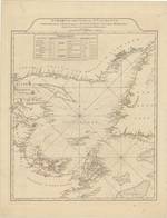
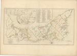
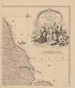
A CHART of the HARBOUR of HALIFAX, in NOVA SCOTIA; with JEBUCTO BAY and CAPE SAMBRÔ. also the Islands, Ledges of Rocks, Shoals & Soundings.
Jefferys, Thomas (1719?-1771) (metsző); Morris, Charles (1711-1781) (közrem.); Sayer, Robert (1725-1794) (közreadó); Bennett, John (?-1787) (közreadó) (Printed for & sold by Rob.t Sayer & Jn.o Bennett, 1775) -
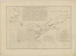
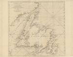
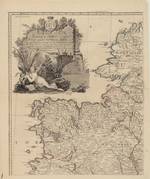
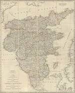
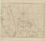
A GENERAL CHART OF THE ISLAND OF NEWFOUNDLAND with the Rocks & Soundings
Jefferys, Thomas (1719?-1771) (közrem.); Cook, James (1728-1779) (alapján); Lane, Michael (alapján); Sayer, Robert (1725-1794) (közreadó); Bennett, John (?-1787) (közreadó) (publish'd ... by Thomas Jefferys : printed for Rob.t Sayer & Jn.o Bennett, 1775) -
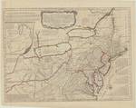
A general MAP of the MIDDLE BRITISH COLONIES in AMERICA: Viz. VIRGINIA, MARYLAND, DELAWARE, PENSILVANIA, NEW-JERSEY, NEW-YORK, CONNECTICUT and RHODE-ISLAND, Of AQUANISHUONIGY the Country of the Confederate Indians, Comprehending AQUANISHUONIGY proper, their Places of Residence, OHIO and THUCHSOCHRUNTIE their Deer Hunting Countries, COUCHSACHRAGE and SKANIADARADE their Beaver Hunting Countries, Of the LAKES ERIE, ONTARIO and CHAMPLAIN, EXHIBITING the ANTIENT and PRESENT SEATS of the INDIAN NATIONS
Evans, Lewis (c. 1700-1756) (alapján); Jefferys, Thomas (1719?-1771) (alapján); Sayer, Robert (1725-1794) (közreadó); Bennett, John (?-1787) (közreadó) (sold by R. Sayer ... & T. Jefferys [! Sayer & Bennett], 1775) -
A MAP of the Island of S.T JOHN In the GULF of S.T LAURENCE, Divided Into Counties & Parishes And the Lots, as granted by Government. to which are added The Soundings round the Coast & Harbours, Improv'd from the late Survey of Captain Holland
Jefferys, Thomas (1719?-1771) (alapján); Sayer, Robert (1725-1794) (közreadó); Bennett, John (?-1787) (közreadó); Holland, Samuel (1728-1801) (közrem.) ([R. Sayer] : [J. Bennett], 1775) -
A MAP OF THE Kingdom of Ireland, Divided into Provinces Counties and Baronies, Shewing The Archbishopricks, Bishopricks, Cities, Boroughs, Market, Towns, Villages, Barracks, Mountains, Lakes, Bogs, Rivers, Bridges, Ferries, Passes, Also the Great, the Branch, & the By Post Roads, together with the Inland Navigation &c
Rocque, John (c. 1704-1762) (kész.); Sayer, Robert (1725-1794) (közreadó) -
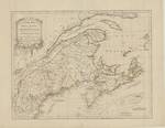
A NEW MAP of NOVA SCOTIA, and CAPE BRETON ISLAND with the adjacent parts of NEW ENGLAND and CANADA,
Jefferys, Thomas (1719?-1771) (alapján); Sayer, Robert (1725-1794) (közreadó); Bennett, John (?-1787) (közreadó); Mead, Bradock (c. 1688-1757) (alapján) (printed & sold by R. Sayer & J. Bennett, 1775) -
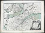
A NEW MAP OF THE PROVINCE OF QUEBEC, - according to THE ROYAL PROCLAMATION, of the 7.th of October 1763. from THE FRENCH SURVEYS Connected with those made after the War.
Carver, Jonathan (1710-1780) (kész.); Sayer, Robert (1725-1794) (közreadó); Bennett, John (?-1787) (közreadó) (printed for Rob.t Sayer and John Bennett, 1776) -
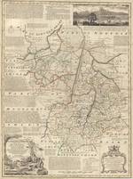
An ACCURATE MAP of CAMBRIDGESHIRE Divided into its HUNDREDS.
Bowen, Emanuel (1693/94-1767); Wilkinson, Robert (közreadó); Sayer, Robert (1725-1794) (közreadó); Bowles, Carington (1724-1793) (közreadó) (printed for Rob. Wilkinson ... R. Sayer ... Carington Bowles, 1787) -
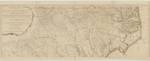
AN ACCURATE MAP OF NORTH AND SOUTH CAROLINA WITH THEIR INDIAN FRONTIERS, Shewing in a distinct manner all the MOUNTAINS, RIVERS, SWAMPS, MARSHES, BAYS, CREEKS, HARBOURS, SANDBANKS and SOUNDINGS on the COASTS; with The ROADS and INDIAN PATHS; as well as The BOUNDARY or PROVINCIAL LINES, The Several TOWNSHIPS and other divisions of the LAND IN BOTH THE PROVINCES;
Mouzon, Henry (1741-1807) (kész.); Sparrow, Samuel (metsző); Sayer, Robert (1725-1794) (közreadó); Bennett, John (?-1787) (közreadó) (printed for Rob.t Sayer and J. Bennett, 1776) -
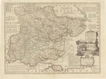
An ACCURATE MAP of the COUNTY of ESSEX, Divided into its HUNDREDS;
Bowen, Emanuel (1693/94-1767) (kész.); Wilkinson, Robert (közreadó); Bowles, Carington (1724-1793) (közreadó); Sayer, Robert (1725-1794) (közreadó) (printed for Rob. Wilkinson, ... Carington Bowles ... Rob.t Sayer, 1787) -
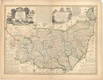
AN ACCURATE MAP of the COUNTY of SUFFOLK Divided into its HUNDREDS.
Bowen, Emanuel (1693/94-1767) (kész.); Bowles, Thomas (?-1767) (közreadó); Bowles, John (ca 1701-1779) (közreadó); Sayer, Robert (1725-1794) (közreadó) (printed for T. Bowles ... John Bowles & Son ... Rob.t Sayer, 1763) -
ENGLAND AND WALES Drawn from the most accurate Surveys - Containing all the Cities Boroughs Market Towns & Villages, In which are included all the Improvements and Observations both Astronomical and Topographical, which have been made by Members of the Royal Society, & others Down to the present Year.
Rocque, John (c. 1704-1762) (kész.); Sayer, Robert (1725-1794) (közreadó) (printed for Rob.t Sayer, 1761) -
ITINERAIRE ANGLOIS CONTAINING The GREAT, DIRECT, and CROSS ROADS, THROUGH ENGLAND AND WALES; with the Distances from Town to Town;
Jefferys, Thomas (1719?-1771) (kész.); Sayer, Robert (1725-1794) (közreadó); Bennett, John (?-1787) (közreadó) (published ... by R. Sayer and J. Bennett, 1775) -
The COAST OF WEST FLORIDA and LOUISIANA The PENINSULA and GULF of FLORIDA or CHANNEL of BAHAMA with the BAHAMA ISLANDS. - By Tho.s Jefferys Geographer to His Majesty.
Sayer, Robert (1725-1794) (közreadó); Bennett, John (?-1787) (közreadó); Jefferys, Thomas (1719?-1771) (alapján) (printed for Rob.t Sayer, 1775)