


A CHART of NORTH and SOUTH AMERICA, including the ATLANTIC and PACIFIC OCEANS, with the nearest COASTS of EUROPE, AFRICA, and ASIA.
CHART containing part of the ICY SEA with the adjacent Coast of ASIA and AMERICA.;
CHART comprizing GREENLAND with the COUNTRIES and ISLANDS about BAFFIN's and HUDSON's BAYs.;
CHART, containing the Coasts of CALIFORNIA, NEW ALBION, and RUSSAIN DISCOVERIES to the North; with the Peninsula of KAMCHATKA, in ASIA, opposite thereto; And ISLANDS, dispersed over the PACIFIC OCEAN, to the North of the LINE.;
CHART of the ATLANTIC OCEAN, with the BRITISH, FRENCH, & SPANISH Settlements in NORTH AMERICA, and the WEST INDIES; as also on the Coast of AFRICA - By Th.s Jefferys Geographer to His Majesty.;
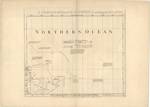
CHART containing the greater part of the SOUTH SEA to the South of the LINE, with the ISLANDS dispersed thro' the same.;
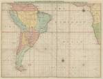
CHART of South AMERICA, comprehending the WEST INDIES, with the Adjacent ISLANDS, in the SOUTHERN OCEAN, and SOUTH SEA.
Dátum
1753Kapcsolódó földrajzi helyek
[Ca 1:16 000 000]Amerika
Atlanti-óceán
Csendes-óceán
Location / Jelzet
TR 1 750Metadata
A tétel részletes adataiKapcsolódó tételek
Cím, szerző, létrehozó, és tárgyszó szerint kapcsolódó tételek mutatása.
-
A CHART of NORTH and SOUTH AMERICA, including the ATLANTIC and PACIFIC OCEANS, with the nearest COASTS of EUROPE, AFRICA, and ASIA.
(publish'd...by T. Jefferys, 1753)

