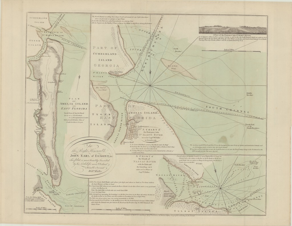
PLAN OF AMELIA ISLAND IN EAST FLORIDA
A CHART of the Mouth of NASSAU RIVER with the BAR and the Soundings on it;
A CHART of the Entrance into ST MARY'S RIVER
| dc.contributor | Fuller, William (kész.) | |
| dc.contributor | Jefferys, Thomas (1719?-1771) (közreadó) | |
| dc.contributor | De Brahm, William Gerard, (1717-1799) (alapján) | |
| dc.coverage.spatial | Amelia-sziget: [1:61 000] Scale of Miles, 3 [= 75 mm] ; St. Mary folyó: [1:21 000] Scale of Miles, 2 [= 148 mm] ; Nassau folyó: [1:31 000] Scale of Miles, 3 [= 147 mm] | |
| dc.coverage.spatial | Amelia-sziget | |
| dc.coverage.spatial | St. Marys (folyó) | |
| dc.coverage.spatial | Nassau (folyó) | |
| dc.date.accessioned | 2016-03-11T20:36:05Z | |
| dc.date.available | 2016-03-11T20:36:05Z | |
| dc.date.copyright | 1770 | |
| dc.date.issued | 1770 | |
| dc.identifier.uri | https://ds.oszk.hu/xmlui/handle/123456789/94057 | |
| dc.description | Fokhálózatok nélkül | |
| dc.description | Északi vagy északhoz közeli tájolások, irányrózsával | |
| dc.description | A Florida keleti partja mellett fekvő Amelia-sziget, valamint a tőle északra, ill. délre lévő két folyó, Nassau és St. Mary torkolatának hajózási térképei | |
| dc.description | Az Amelia-szigetet ábrázoló térkép W. G. de Brahm térképe alapján készült | |
| dc.description | Teljes kiadói felirat: Published 26 March 1770 according to Act of Parliament by Thomas Jefferys Geographer to the King, in the Strand. | |
| dc.format.extent | 1 térkl., 3 társtérk. | |
| dc.format.medium | rézmetszet, kézi szín. | |
| dc.format.medium | 50,5x16, 35x44,5, 35x15,5 cm | |
| dc.publisher | published... by Thomas Jefferys | |
| dc.title | PLAN OF AMELIA ISLAND IN EAST FLORIDA | |
| dc.title | A CHART of the Mouth of NASSAU RIVER with the BAR and the Soundings on it | |
| dc.title | A CHART of the Entrance into ST MARY'S RIVER | |
| dc.title.alternative | Amelia-sziget, Nassau (folyó), St. Marys (folyó) (közlekedési térkép) (1770) | |
| dc.type | Cartographic | |
| dc.type | hajózási térkép | |
| dc.publication | [London] : published... by Thomas Jefferys, 1770 | |
| dc.identifier.collection | OSZK-2632763 | |
| dc.identifier.location | TR 1 897 |