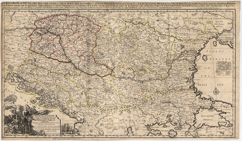


The kingdom of Hungary and the states that have been subject to it which are now the northern parts of Turkey in Europe
Carte d'Hongire, qui contient les estats qui leurs apartenoient, ee qui fait anjourd-hui la partie septentrionale de la Turquie en Europe, et qui contient la route;
The kingdom of Hungary and the states that have been subject and depended on that crown viz Transilvania, Moldavia, Valachia, Croatia, Bosnia, Dalmatia, Servia, Bulgaria...
| dc.contributor | Sanson, Guillaume (1633-1703) (alapján) | |
| dc.contributor | Rocque, John (c. 1704-1762) (közread.) | |
| dc.coverage.spatial | [1:1 800 000] 15 comm. leagues of Germany [=60 mm] | |
| dc.coverage.spatial | Magyarország | |
| dc.coverage.spatial | Délkelet-Európa | |
| dc.date | [ca. 1755] | |
| dc.date.accessioned | 2016-05-13T01:39:56Z | |
| dc.date.available | 2016-05-13T01:39:56Z | |
| dc.identifier.uri | https://ds.oszk.hu/xmlui/handle/123456789/51415 | |
| dc.description | Megjelenési idő a kiadó címe alapján | |
| dc.description | Teljes méret kereten kívüli feliratokkal: 55,4x94,7 cm | |
| dc.format.extent | 1 térkl. | |
| dc.format.medium | rézmetszet, kézi szín. | |
| dc.format.medium | 51x92,8 cm | |
| dc.publisher | sold by J. Rocque near Round Court in the Strand | |
| dc.title | The kingdom of Hungary and the states that have been subject to it which are now the northern parts of Turkey in Europe | |
| dc.title | Carte d'Hongire, qui contient les estats qui leurs apartenoient, ee qui fait anjourd-hui la partie septentrionale de la Turquie en Europe, et qui contient la route | |
| dc.title | The kingdom of Hungary and the states that have been subject and depended on that crown viz Transilvania, Moldavia, Valachia, Croatia, Bosnia, Dalmatia, Servia, Bulgaria... | |
| dc.title.alternative | Magyarország (általános térkép) (1755) | |
| dc.type | Cartographic | |
| dc.publication | London : sold by J. Rocque near Round Court in the Strand, [ca. 1755] | |
| dc.identifier.collection | OSZK-1079814 | |
| dc.identifier.location | TR 2 841 |