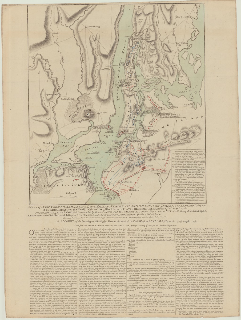
A PLAN of NEW YORK ISLAND, with part of LONG ISLAND, STATEN ISLAND & EAST NEW JERSEY, with a particular Description of the ENGAGEMENT on the Woody Heights of Long Island, between FLATBUSH and BROOKLYN, on the 27.th of August 1776. between HIS MAJESTY'S FORCES Commended by General Howe and the AMERICANS under Major General PUTNAM, - Shewing also the Landing of the BRITISH ARMY on New-York Island, and the Taking of the CITY of NEW YORK &c. on the 15.th of September following, with the Subsequent Disposition of Both the Armies
| dc.contributor | Faden, William (1750-1836) (metsző és közreadó) | |
| dc.coverage.spatial | [1:85 000] 3 Miles [= 58 mm] | |
| dc.coverage.spatial | New York (város) | |
| dc.date.accessioned | 2016-03-11T19:54:17Z | |
| dc.date.available | 2016-03-11T19:54:17Z | |
| dc.date.copyright | 1776 | |
| dc.date.issued | 1776 | |
| dc.identifier.uri | https://ds.oszk.hu/xmlui/handle/123456789/94063 | |
| dc.description | A brit és az amerikai csapatok között 1776. aug. 27-én lezajlott Woody Heights-i (Long Island) ütközetnek, valamint New York 1776. szept. 15-i brit bevételének a térképe | |
| dc.description | Fokhálózat nélkül | |
| dc.description | Teljes méret a lemezhatárig: 51,6x44 cm ; a papírszélekig: 74,5x56 cm | |
| dc.description | Atlaszban is megjelent ; hátoldalon nyomtatott sorszám: 17 | |
| dc.description | A szöveges ismeretető végén található készítői és forgalmazói felirat: Engaved by W. FADEN, (Successor to the late Mr. JEFFERYS, Geographer to the King) the Corner of St. Martin's-Lane, Charing-Cross, and to be had of Mr. WALLIS Bookseller in Ludgote-Street. | |
| dc.format.extent | 1 térkl. | |
| dc.format.medium | rézmetszet, kézi szín. | |
| dc.format.medium | 47,2x41,8 cm | |
| dc.publisher | publish'd... by W.m Faden | |
| dc.title | A PLAN of NEW YORK ISLAND, with part of LONG ISLAND, STATEN ISLAND & EAST NEW JERSEY, with a particular Description of the ENGAGEMENT on the Woody Heights of Long Island, between FLATBUSH and BROOKLYN, on the 27.th of August 1776. between HIS MAJESTY'S FORCES Commended by General Howe and the AMERICANS under Major General PUTNAM, - Shewing also the Landing of the BRITISH ARMY on New-York Island, and the Taking of the CITY of NEW YORK &c. on the 15.th of September following, with the Subsequent Disposition of Both the Armies | |
| dc.title.alternative | New York (környék) (hadtörténelmi térkép) (1776) | |
| dc.type | Cartographic | |
| dc.type | hadműveleti térkép | |
| dc.publication | London : publish'd... by W.m Faden, 1776 | |
| dc.identifier.collection | OSZK-1066728 | |
| dc.identifier.location | TR 1 910 |
A tételhez tartozó fájlok
Ez a tétel a következő gyűjteményekben található meg
Kapcsolódó tételek
Cím, szerző, létrehozó, és tárgyszó szerint kapcsolódó tételek mutatása.